Quick answer
Before each outdoor flight in mainland China, check your exact takeoff location, the planned altitude and date, and the latest official airspace classification. The CAAC UOM portal and applicable local government airspace announcements are the primary sources. A green mark in a DJI app or a successful drone registration does not by itself establish permission to fly.
A five-check method for your exact spot
- Choose the exact place — city, district, park entrance, scenic area and intended takeoff point. Do not decide from a city name alone.
- Open the official source — start at uom.caac.gov.cn and locate the current flight/airspace query option. Local governments sometimes provide a separate live flight-service map; use the applicable government link rather than search-result screenshots.
- Zoom to the intended location — confirm the marker and nearby boundaries. A few hundred meters may change the result; do not rely on a broad, low-zoom screenshot.
- Check drone class, actual altitude and time — map labels, altitude bands, temporary events and local venue restrictions can alter the answer. Under the national framework, the area above true height 120 meters requires special scrutiny even if a nearby low-altitude area is suitable.
- Determine the action — an ordinary qualifying flight in a government-designated permitted area may not require a flight-activity application; a controlled area generally requires approval. A separate municipal rule or site manager may still restrict takeoff.
Do not take off when the live classification or a required approval cannot be verified.
What the colors actually mean
Never assume one nationwide color legend. The meaning of a color or hatch pattern depends on the specific official map being displayed and its date.
For example, Shanghai's 2026 official published map uses green to denote airspace below true height 120 meters designated as suitable for micro, light and small UAV operations; outside that designated area the municipal notice calls the airspace controlled. This Shanghai definition cannot be copied to an unrelated map in another city.
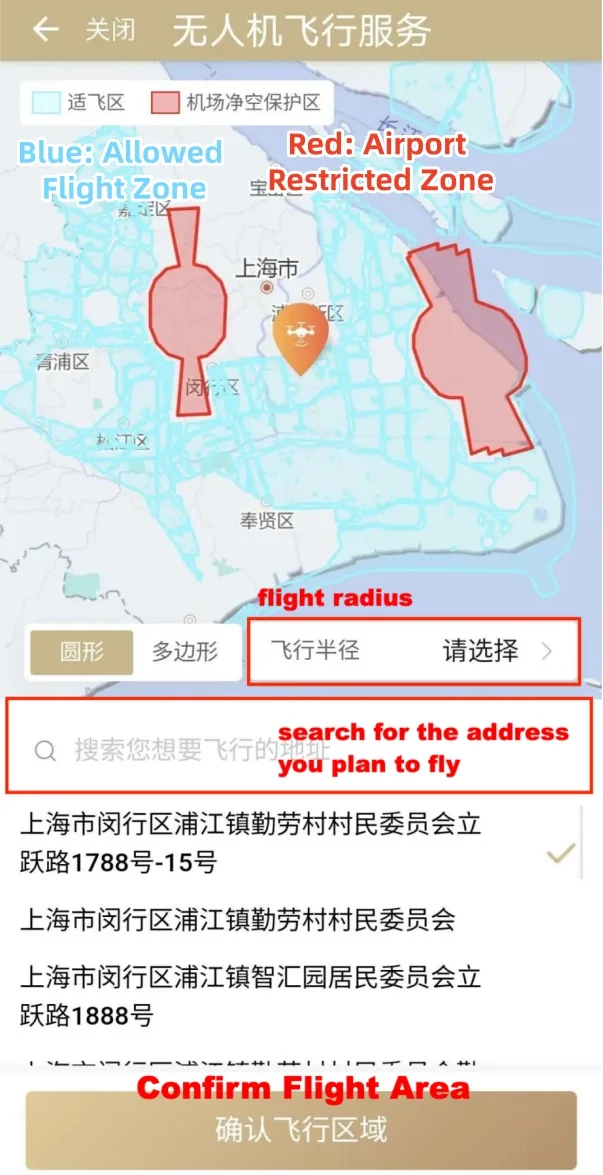
UOM map versus DJI GEO
| Question | Official UOM / local airspace authority | DJI GEO / device app |
|---|---|---|
| Who sets legal controlled/permitted airspace? | Relevant state and local authorities | Not a replacement for authorities |
| May the device refuse takeoff? | Not the same as device geofencing | DJI software can restrict flight |
| Does a DJI unlock grant legal approval? | Official aviation approval is a separate question | No |
| What changes with a major event? | Government notices and temporary airspace control | App map updates can lag or differ |
Use the official government source for legal permission and the device maker's map for the separate question of whether the aircraft will technically arm or launch.
If you cannot read the Chinese map
Keep the Chinese place-name characters from your hotel or map app, not just a phonetic spelling. Save the exact official URL, date and a screenshot showing the point and the map legend. Translate the labels rather than guessing from colors. If the page cannot load from your country, retry the official URL on a normal supported browser and consult the local published notice; do not treat an inaccessible page as proof that the airspace is permitted.
Already know you need permission? See registration versus flight approval. Need help signing in? Use the UOM access recovery guide.
Common questions
Can I fly anywhere that DJI shows as unrestricted?
No. DJI geofencing and government-defined airspace restrictions answer different questions.
Is the UOM QR code sufficient to fly?
No. It establishes registration-related information, not a location- or date-specific flight authorization.
Is all of China below 120 meters open?
No. Controlled airspace and local restrictions still apply at low altitudes.
Can I rely on a photo of last year's airspace map?
No. Check the currently applicable government map and any temporary event controls.